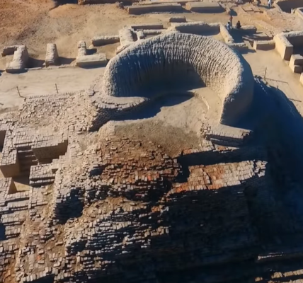
Between 1954 and 1958, a survey of the coastline of Kutch, Kathiawar, and South Gujarat by the Archaeological Survey of India (ASI) revealed several Harappan settlements, many of them ports located at the mouths of rivers. Of all these, Lothal, excavated by the ASI between 1955 and 1962, revealed the world’s first dockyard, built by the ancient Indians around 4500 years ago. This was a significant moment, as it was the first Indus site discovered to be associated with maritime activities.
Lothal, situated about 52 miles from Ahmedabad, was identified as a trading hub and warehouse for goods such as rice, cotton, and wheat, which were exported, and raw materials like gemstones and metals, which were imported.
Lothal
Lothal in Gujrati is formed by combining the words Loth and Thal meaning “mound of the dead”. However, some scholars suggest that Lothal is a combination of the Sanskrit words Lodh and Sthal meaning “a place where boats are moored or repaired”.
Lothal covers an area of 7.5 hectares, with layers of settlement built up over time. Excavations show two main cultural periods at the site. First, a local chalcolithic (Copper Age) community settled here, using distinctive red pottery. Later, the Indus people arrived and developed the site further, creating an organized urban center. Initially, Lothal was a small village with mud-brick houses on higher ground, surrounded by an earthen wall to prevent flooding. A major flood led to a reconstruction, expanding it into a well-planned town with two main areas: the Acropolis, where larger buildings like the ruler’s mansion and warehouse were located, and the Lower Town, with homes, workshops, and markets. A dock on the eastern side connected the town to the sea via the Bhogavo-Sabarmati-Gulf of Cambay route.
Lothal, peaked around 2300 BCE as a major maritime trade hub. Its strategic location near the Gulf of Khambhat enabled it to thrive through trade with Mesopotamia, the Persian Gulf, and other regions. However, by 1900 BCE, it was destroyed by a great flood.
The Dock and the Warehouse
The dock at Lothal was a large, rectangular basin with brick walls surrounding it, shaped like a trapezoid. It measured about 700 feet long and 120 feet wide. The walls, built of fired bricks, were thick and sturdy, with a smooth vertical inner side to allow ships to dock right up against them. The dock had an inlet channel on one side, which let water flow in and out, allowing boats to enter. To manage water levels, there was an outlet, or spillway, on the opposite side, which helped drain excess water. The dock’s floor had anchor stones to tie boats, and the walls were built with small holes for controlling water pressure. This careful design shows it was built to handle the flow of tidal water and support trade activities. It is estimated that the Lothal dock could have accommodated around 20 to 30 boats simultaneously. The boats it could berth were medium-sized, likely ranging up to 60 feet in length and capable of displacing up to 60 tons of cargo.
On the dock’s western side was a large, sturdy mud-brick platform that served as a working area for loading and unloading goods. The warehouse stood nearby, overlooking the dock, which made it easy for workers to transport cargo between the ships and the storage area. The warehouse was a spacious building designed to keep goods safe and secure. It had thick brick walls and a raised platform to protect it from flooding and moisture. Inside, the warehouse was divided into multiple sections or chambers, where different types of cargo—like beads, pottery, shells, and metals—could be stored. The layout allowed for easy access to goods, facilitating organization and efficient handling of trade items.
Together, the dock and warehouse reflected Lothal’s role as a bustling trade center, where goods could be efficiently transferred from ships, stored, and then transported to other parts of the Indus civilization and beyond.

Dock or Not?
Some scholars questioned whether the structure at Lothal was a dock, proposing instead that it might have been a reservoir or a tank for storing water. Their skepticism stemmed from doubts about whether Lothal had been close enough to the sea to allow ships to dock, given that the sea is about 10 to 20 kilometers (6 to 12 miles) from Lothal, and the Sabarmati river flows 20 kilometers away.
However, Dr. S.R. Rao, the chief archaeologist at Lothal, presented several compelling arguments in favor of the idea that the structure at Lothal, built by the ancient Indians, was indeed the world’s first dockyard:
1. He pointed out the design features such as the smooth, vertical walls that were ideal for docking ships, contrasting them with the stepped structure of a water tank.
2. The dock’s spillway and inlet channel, designed to control tidal water flow and prevent silt buildup, were complex features unnecessary for a simple water tank.
3.. The presence of offsets in the walls to withstand water pressure and weep holes for seepage control further suggested that the structure was intended to hold tidal water.
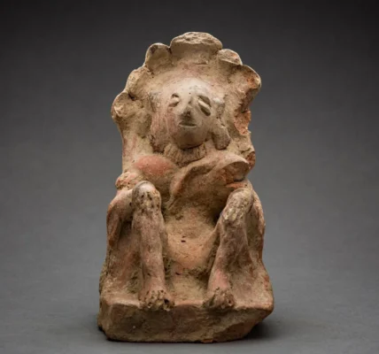
4. Maritime artifacts such as perforated anchor stones and terracotta boat models with masts and oar placements pointed to a vibrant maritime culture.

5. The saline soil and estuarine shells found inside the structure indicated that seawater once filled the dock, making it unsuitable for use as a freshwater tank.
6. Expert opinions, such as those from H.P. Oza, Director of Ports for Gujarat, reinforced the idea that the structure was a dock, with evidence of a tidal channel likely connecting Lothal to the sea.
7. Nearby shrines to Vanatimata, the sea goddess, and local traditions of making offerings before sailing further supported the view of Lothal as a maritime hub.
8. Rao also compared the structure to the smaller Gogha dock, which shared similar features, further bolstering his argument.
While Rao’s analysis of structural features, artifacts, salinity, expert opinions, and comparisons with other ports strongly suggested that Lothal’s structure was purpose-built for maritime trade, it must be noted that this was all circumstantial evidence, not scientific proof.
A Study of Marine Microfossils Proves Lothal Structure was a Dock
In a study of the microfossils deposited in the rectangular structure (dock) by Rajiv Nigam (National Institute of Oceanography) in 2006, well-preserved in situ foraminifera assemblages were encountered. These assemblages were found to be comparable with those found in marginal marine environments (Nigam, 1988). Based on this evidence, the study concluded that the rectangular structure was a dockyard, connected to the open marine environment with a high tidal range.

But skeptics still questioned the structure’s function as a dock, citing its location on land, far away from the sea and river. The argument was finally put to rest in a recent study carried out by Ekta Gupta, V. N. Prabhakar, and Vikrant Jain of IIT Gandhinagar.
Final Nail in the Lothal Dockyard Theory : Ancient River Channel Discovered
A recent study published in the Journal of Archaeological Science in October 2024 provides conclusive evidence that the structure at Lothal was indeed a dockyard, settling the long-standing archaeological debate. The study, conducted by Ekta Gupta, V.N. Prabhakar, and Vikrant Jain from IIT Gandhinagar, used a combination of early maps, satellite imagery, and Digital Elevation Models (DEMs) to examine the region’s historical hydrology and geography. By analyzing the shifting course of the Sabarmati River and the surrounding landscape, the researchers confirmed that the river once flowed directly through Lothal, connecting it to important trade routes. The study also integrated multi-temporal and multi-spectral satellite data, which revealed old river channels and palaeocoastal features, further supporting the theory that Lothal was a vital port linked to both river and sea trade routes.
According to a statement from the Press Information Bureau (PIB), “Satellite images have unveiled the old channels of the River Sabarmati, suggesting Lothal’s key location on a significant river route linked to Koth and other resource-rich areas, as well as to the Little Rann of Kachchh through the Nal Sarovar.” This research underscores Lothal’s strategic importance as a trade hub, confirming the dockyard theory and addressing previous concerns regarding ancient waterways or natural channels that once connected the Lothal region to the sea or river systems.
Prabhakar explained, “Using the technology, we found that the shifting Sabarmati river aligns with Lothal’s location, indicating that the river flowed through the region during the time of the Harappan port. The study shows that Lothal was part of a network linking Gujarat’s Gulf of Khambhat to places like Dholavira and Mesopotamia, enabling traders to travel by boat and transport goods.”
This study, through its innovative use of satellite data and geomorphological analysis, definitively proves that Lothal structure was an ancient dockyard, the world’s first dockyard built by the ancient Indians, marking a monumental discovery in the history of ancient maritime trade.
The Lothal Dockyard as a Key Port for Ancient Global Trade
Lothal played a central role in the maritime trade network connecting ancient India with civilizations in Mesopotamia, the Persian Gulf, and possibly Egypt. This trade facilitated the exchange of goods and cultural practices, leaving behind significant archaeological evidence.

Trade Goods: Lothal’s trade involved imports and exports, such as:
- Stone and Beads: Agate and carnelian were imported for bead-making.
- Copper: High-purity copper ingots were imported from Susa and Oman.
- Exports: Lothal exported ivory, shell inlays, gemstones, cotton goods, and conch shells.
- Exotic Goods: Items like shell bangles, Indus seals, and gold pendants highlight extensive trade.
Evidence of Trade and Cultural Exchange: Artifacts like Indus-style seals, terracotta sealings, and carnelian beads point to Lothal’s connections with the Gulf, Mesopotamia, and beyond. The discovery of weights and measures indicates a standardized system of commerce.
Cultural Interactions: Lothal also shows signs of cultural exchange, with artifacts resembling Sumerian and Egyptian influences, suggesting interactions with these regions.
Role of Intermediaries: Merchants from regions like Dilmun helped sustain trade links when direct contact with Mesopotamia diminished, ensuring Lothal’s ongoing role in international trade.
In sum, Lothal, home to the world’s first dockyard built by the ancient Indians, played a pivotal role in connecting civilizations across the globe, influencing and being influenced by the broader world through its dynamic trade network.
References:
- Gupta, E., Prabhakar, V. N., & Jain, V. (2024). Sabarmati and its connection with the Harappan port Lothal and the Nal corridor: A study using multi-sensor data, cloud-computing and multi-platforms. Journal of Archaeological Science, 170, 106046. https://doi.org/10.1016/j.jas.2024.106046
- Nigam, R. (2006). Foraminifera [Marine Microfossil] as an additional tool for archaeologists – Examples from the Arabian Sea. National Institute of Oceanography. Retrieved from https://www.researchgate.net/publication/27667625
- Rao, S. R. (1979). Lothal: A Harappan port town, 1955-62 (Vol. 1). Archaeological Survey of India.
- Rao, S.R.. “Shipping and Maritime Trade of the Indus People.” Expedition Magazine 7, no. 3 (May, 1965): https://www.penn.museum/sites/expedition/shipping-and-maritime-trade-of-the-indus-people/


